South Florida Local News
Florida Fish and Wildlife Conservation Commission approves updated boundary coordinates for coral formation protection zones in John Pennekamp Coral Reef State Park to enhance reef conservation and sustainable lobster harvesting
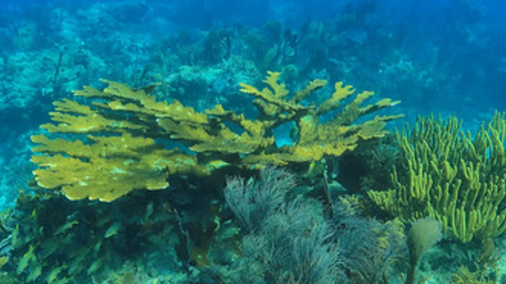
Key Largo, Florida – The Florida Fish and Wildlife Conservation Commission (FWC) has approved significant changes to the boundary coordinates of seven Coral Formation Protection Zones within John Pennekamp Coral Reef State Park, a move aimed at bolstering coral reef conservation while balancing access for sustainable lobster harvesting. The decision, made during the Commission’s August meeting, represents the latest effort by state authorities to protect Florida’s fragile coral ecosystems while accommodating recreational and commercial use of surrounding waters.
The updated boundaries will apply to Turtle Rocks, Basin Hill, Higdon’s Reef, Cannon Patch, Mosquito Bank North, Mosquito Bank Southeast, and Three Sisters, according to FWC officials. The modifications are designed to enhance protection of areas with dense coral growth, while simultaneously opening adjacent sandy and seagrass habitats for lobstering activities. Officials emphasized that the changes are a direct result of ongoing scientific research and careful consideration of both ecological and economic factors.
To aid compliance, the revised zones will be clearly marked on the water with buoys, providing boaters, divers, and fishers with a visual guide to avoid sensitive coral areas. The updated coordinates are set to take effect on July 1, 2026, giving stakeholders ample time to adjust their practices and prepare for the changes. “With these updates, we are continuing our commitment to protect coral reef habitats while also considering the needs of the fishing community,” said a spokesperson for the FWC. “The modifications to the boundary coordinates ensure that our coral reefs remain healthy for future generations while providing opportunities for sustainable lobster harvest in areas that do not contain sensitive coral formations.”
John Pennekamp Coral Reef State Park, located in Key Largo, holds the distinction of being the first underwater park in the United States. It encompasses a portion of the only living coral reef in the continental country, making it an ecological treasure of national significance. Coral Formation Protection Zones were originally established in 1994 to safeguard the reef from potential damage caused by anchoring, fishing equipment, and other human activities. These zones have played a critical role in maintaining the structural and biological integrity of the reef over nearly three decades.
The newly approved changes reflect a delicate balance between conservation and sustainable use. By restricting access to areas with dense coral coverage, the FWC aims to prevent physical damage to fragile reef structures, which provide essential habitat for countless marine species. At the same time, expanding access to sandy and seagrass areas allows commercial and recreational fishers to continue harvesting lobsters without compromising reef health. This approach underscores the agency’s ongoing strategy to manage Florida’s marine resources in a way that protects biodiversity while supporting economic activity.
Experts have long stressed the importance of coral reefs for ecological and human communities alike. Coral formations act as natural barriers, protecting coastlines from erosion and storm damage while providing habitat for fish, invertebrates, and other marine life. The reefs also contribute significantly to Florida’s economy through tourism and fishing industries. Protecting these ecosystems is therefore essential for both environmental sustainability and economic resilience.
“The updated zones represent a thoughtful, science-based approach to managing one of Florida’s most valuable marine resources,” said a marine biologist familiar with the project. “By identifying high-risk areas and directing human activity toward less sensitive habitats, the FWC is helping ensure that John Pennekamp’s reefs can thrive for decades to come.”
Boaters, divers, and fishers who frequent John Pennekamp Coral Reef State Park are encouraged to familiarize themselves with the new boundaries once they are implemented. The FWC plans to provide educational resources, maps, and online guidance to ensure that the public can comply with the updated regulations. Officials stress that adherence to these boundaries is crucial, not only for protecting coral reefs but also for sustaining the region’s vibrant fishing and recreational industries.
The Commission’s August meeting agenda, which includes background reports and detailed maps of the new Coral Formation Protection Zones, is available on the FWC website under “The Commission” and “Commission Meetings.” This level of transparency allows stakeholders, including environmental groups, recreational users, and commercial fishers, to understand the rationale behind the boundary changes and to engage in ongoing conservation efforts.
Local businesses that rely on tourism and fishing in the Key Largo area have responded positively to the news, noting that a healthy reef system is vital for attracting visitors and supporting livelihoods. “The reef is our biggest asset,” said a dive shop owner in Key Largo. “When the reef is protected, it means we have more opportunities for eco-tourism, diving trips, and sustainable fishing. These updates are a win-win for the environment and our community.”
At the same time, the FWC acknowledges that any change in boundaries requires adjustment by commercial fishers. Lobster harvesters will need to update their navigation plans to align with the revised zones, ensuring that traps are set in areas that do not interfere with protected coral formations. According to officials, these adjustments are expected to be relatively straightforward, thanks to the clear placement of buoys and detailed maps accompanying the new boundaries.
The move also reflects a broader trend in Florida’s approach to environmental management, emphasizing adaptive strategies that consider both human use and ecosystem health. Over the years, FWC officials have implemented a variety of measures, from seasonal closures to gear restrictions, all aimed at mitigating human impact on sensitive marine habitats. The newly revised Coral Formation Protection Zones represent the latest chapter in this ongoing effort.
“By combining science, careful planning, and public engagement, we can manage these waters in a way that allows people to enjoy natural resources while preserving them for future generations,” the FWC spokesperson said. “This is exactly what the updated Coral Formation Protection Zones aim to achieve.”
The updated coordinates are expected to have a dual effect: they will limit human activity in ecologically sensitive areas, reducing the risk of physical damage to corals, and they will provide new opportunities for lobstering in noncoral habitats. Officials believe this approach is a model for how conservation and sustainable resource use can coexist.
As the July 2026 implementation date approaches, the FWC will continue to work with local stakeholders, scientists, and enforcement agencies to ensure smooth adoption of the new boundaries. Public outreach campaigns, educational materials, and online mapping tools will play a key role in helping the community understand and respect the revised zones.
The FWC’s ongoing stewardship of John Pennekamp Coral Reef State Park highlights the importance of proactive management in the face of growing human activity and environmental pressures. By updating the boundaries of these seven Coral Formation Protection Zones, the Commission is taking concrete steps to protect Florida’s only living continental reef while accommodating sustainable fishing practices.
The park’s reefs are not only ecologically important but also hold cultural and educational value. They serve as a living classroom for researchers, students, and tourists interested in learning about marine ecosystems, coral biology, and the delicate balance between conservation and human activity. Protecting these zones ensures that the park can continue to serve as a site for research, recreation, and education for generations to come.
In conclusion, the FWC’s approval of the new boundary coordinates for Turtle Rocks, Basin Hill, Higdon’s Reef, Cannon Patch, Mosquito Bank North, Mosquito Bank Southeast, and Three Sisters reflects a carefully considered effort to preserve Florida’s coral reef habitats. The changes enhance protection of sensitive areas, provide guidance for responsible lobstering, and underscore the Commission’s commitment to sustainable marine resource management. By taking these steps, Florida continues to demonstrate its leadership in balancing environmental protection with human use, ensuring that its unique coral reef ecosystems remain healthy, vibrant, and accessible for years to come.


The Wheel in Motion financial literacy series announces June and July lineup

Flood recovery grant applications open to help residents impacted by recent disaster access housing repair and rebuilding assistance programs
Public transportation becomes the smartest way to experience the World Cup in South Florida

Broward County announces expanded overnight aerial mosquito spraying operations scheduled for June 6 and June 9

Emergency sewer main replacement project to bring traffic detours and road closures along SE 12th Avenue and East Las Olas Boulevard

More than 500 families and community members to attend the first BCPS Parent AI Symposium

Pine Crest Upper School student-athlete earns prestigious national Academic All-American recognition

UKG warns World Cup may trigger $17 billion in global workplace productivity losses across multiple countries

South Florida community celebrates girls and teens with disabilities at 2026 Miss Arc Broward Pageant

West Palm Beach to host One Epic Fourth on Flagler for America’s 250th

Mayor Keith A. James appoints Jade Greene as city LGBTQ+ liaison

Broward County Public Schools finishes strong and looks ahead

Marion County woman wins $1 million playing scratch-off game

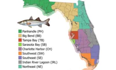
Recreational snook harvest on Florida’s east coast closes today

What property tax proposals could mean for Sunrise residents
-
 South Florida Local News4 days ago
Marion County woman wins $1 million playing scratch-off game
-
 South Florida Local News4 days ago
Recreational snook harvest on Florida’s east coast closes today
-
 South Florida Local News3 days ago
Mayor Keith A. James appoints Jade Greene as city LGBTQ+ liaison
-
 South Florida Local News4 days ago
What property tax proposals could mean for Sunrise residents