South Florida Local News
Snook recreational harvest season opens September 1 across most of Florida

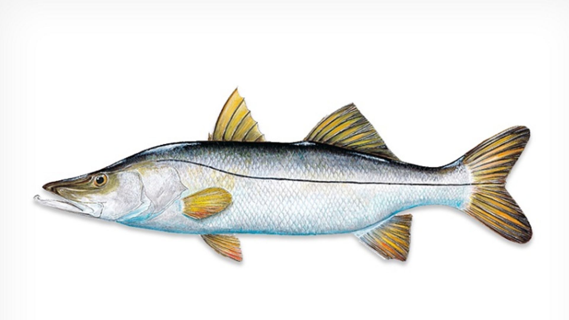
Florida – Florida’s recreational snook harvest season opens September 1 across all three east coast management regions and four of the state’s west coast regions, giving anglers another opportunity to keep the popular inshore fish under rules set by the Florida Fish and Wildlife Conservation Commission.
The season applies to state and inland waters within the Southeast, Indian River Lagoon and Northeast regions on the east coast. On the west coast, recreational harvest will be allowed in the Panhandle, Big Bend, Tampa Bay and Sarasota Bay regions.
The opening is part of Florida’s regional approach to managing snook, a system designed to account for differences among local fisheries rather than treating the entire state as one area. The Florida Fish and Wildlife Conservation Commission, or FWC, uses seven different metrics to evaluate the fishery in each management region.
That approach allows the agency to respond more closely to local conditions and concerns while setting harvest rules for different parts of Florida.
For anglers fishing in the four west coast regions covered by the September 1 opening, the season will remain open through November 30. The daily bag limit is one snook per person, and harvested fish must measure between 28 and 33 inches in total length.
Read also: Fort Lauderdale United FC and Gainbridge support South Florida families with $9,900 YMCA donation
The Panhandle region begins at the Florida-Alabama border and stretches east along the coast to 84°20.800ꞌ West Longitude in Franklin County near Alligator Point. The Ochlockonee Bay, as well as the Ochlockonee River and its tributaries, are not part of this region.
Immediately to the east and south is the Big Bend region. Its western coastal boundary is the same 84°20.800ꞌ West Longitude point near Alligator Point. The region extends as far as Fred Howard Park near the Pasco-Pinellas county line.
The Big Bend region includes the waters of the Ochlockonee, Withlacoochee and Anclote rivers and their tributaries. Those boundaries are important for anglers because regulations can change when moving from one management region into another.
The Tampa Bay region starts at Fred Howard Park and extends south to State Road 64 in Manatee County. Its boundaries include the Alafia, Braden, Manatee and Hillsborough rivers and their tributaries.
There are also exclusions within the Tampa Bay region. Palma Sola Bay is not included, nor are the Anclote River and its tributaries.
Farther south, the Sarasota Bay region begins at State Road 64 in Manatee County and continues to 27°04.727’ North Latitude near the Venice Municipal Airport. Its boundaries include Palma Sola Bay, Phillippi Creek, Cow Pen Slough Canal and Curry Creek. The Braden and Manatee rivers, however, are excluded.
On Florida’s east coast, the recreational snook season beginning September 1 will last longer. Anglers in the Southeast, Indian River Lagoon and Northeast management regions will be able to harvest snook through December 14.
The daily bag limit in those three regions is also one fish per person. The size requirement is slightly different, however, with the slot limit set at 28 to 32 inches in total length.
The Southeast region stretches from the Martin-Palm Beach county line south to the Miami-Dade/Monroe county line. It includes the Hillsboro Canal, Miami Canal, North New River Canal and West Palm Beach Canal, along with the Loxahatchee River and its tributaries.
Lake Okeechobee and Everglades National Park are not included in the Southeast management region.
The Indian River Lagoon region starts at Lytle Avenue/South Causeway in New Smyrna Beach and extends south to the Martin-Palm Beach county line. Its boundaries also include all waters of the Kissimmee River and Lake Okeechobee.
The Loxahatchee and St. Johns rivers and their tributaries are excluded from the Indian River Lagoon region.
The Northeast region covers the northern portion of Florida’s east coast. Its northern boundary is the Florida-Georgia border, while the southern boundary is Lytle Avenue/South Causeway in New Smyrna Beach.
This region includes all waters of the St. Johns River and its tributaries. It does not include the Withlacoochee or Kissimmee rivers, Cypress Lake, or lakes Hatchineha and Kissimmee.
With several regions sharing borders and individual waterways being included or excluded, the FWC’s boundaries are an important part of the regulations. Anglers should make sure they know which management region they are fishing in before keeping a snook.
The regional system is part of the FWC’s broader effort to manage some of Florida’s most popular inshore fisheries. Rather than relying on a single statewide assessment, the agency evaluates conditions region by region and uses the results to guide management decisions.
The FWC also publishes annual reviews for the snook fishery. These reports summarize key findings from the yearly evaluation of the management metrics used in each region.
The September 1 opening therefore marks more than the beginning of another recreational harvest period. It also reflects the state’s ongoing effort to balance angler access with management of the snook population in different parts of Florida.
Anglers looking for the complete regulations, including management region boundaries and annual reviews, can find additional information through the FWC’s official snook regulations page.



Boca Raton chef faces DUI and drug charges after deputies report 102 mph pursuit

Hollywood reminds residents that early voting begins October 19

Broward School Board approves free menstrual products pilot at at least seven schools

Florida permanently protects nearly 1,500 acres across two working cattle ranches

Pine Crest student Alaina Jamal earns recognition for three original poems

Fort Lauderdale opens new water treatment center as part of $666 million project

Broward commissioners approve possible legal action to access sheriff’s headquarters

Man arrested after Pompano Beach shooting leaves one person injured

Overnight lane and ramp closures scheduled on Broward highways through Oct. 29

Sinta Tantra’s Petals of the Moon brings new public art to southern West Palm Beach

DeSantis announces plans for hurricane tax-filing relief as FICPA awaits IRS confirmation

Greater Fort Lauderdale Alliance president and CEO Bob Swindell announces retirement in 2027

Davie extends free tree giveaway with two pickup windows on October 15

Hollywood’s Radius Garage to restrict access during work from October 19 through November 3

New River Middle School earns national certification for its Marine Science and iCAN magnet programs
-
 South Florida Local News5 days ago
DeSantis announces plans for hurricane tax-filing relief as FICPA awaits IRS confirmation
-
 South Florida Local News4 days ago
Overnight lane and ramp closures scheduled on Broward highways through Oct. 29
-
 South Florida Local News5 days ago
Greater Fort Lauderdale Alliance president and CEO Bob Swindell announces retirement in 2027
-
 South Florida Local News5 days ago
Sinta Tantra’s Petals of the Moon brings new public art to southern West Palm Beach